 The Aosta Trip
Cascate del Rutor
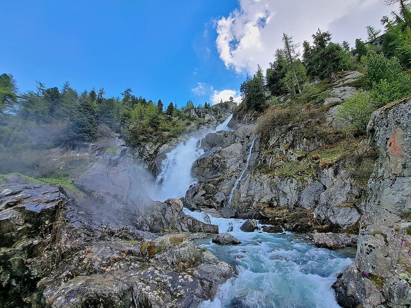
Three falls between 1,700 and 2,000 m; over the third a 16 m steel footbridge, since 2014
The Dora di Rutor descends towards La Joux in three falls inside the conifer forest: the first at 1,700 m, where a wooden bridge crosses it twenty minutes from the start; the second at 1,850 m, which you view from a ledge; the third at about 2,000 m, crossed by a steel footbridge 16 m long and 1.20 m wide, opened in 2014, with Mont Blanc in the background. Near the third fall the rock is constantly wet with spray and slippery. The same path continues to the Rutor lakes and the Rifugio Deffeyes.

Visiting
ACCESS: from La Thuile 3 km of road to La Joux (1,594 m), start at the Bar delle Cascate. The road can only be driven from late spring (snow). In peak season it is closed to cars during the day: from 9:00 to 18:00 according to people who were there in August 2022, from 9:00 to 17:00 in August 2024, with paid car parks at La Joux (€5 a day in 2024); if you arrive before 9:00 you can get through. Blogs and hikers mention a free shuttle from La Thuile, but in the official 2026 shuttle timetables (circular, Colle San Carlo, Little St Bernard) La Joux does not appear: ask the tourist office. ROUTE: path 3/AV2, then 19. First fall and wooden bridge in 20 minutes (return loop on the 19: 1.9 km, 89 m height gain, 34 minutes each way, E, June–September). Second fall in 50 minutes or an hour, third fall and footbridge in 1 h 30 from the start; slippery ground near the third fall; in May there is still snow. For the Rifugio Deffeyes you continue on the same path (2026 data).
Trails
- from Joux (1,613 m) · ↑ 387 m · 1 h 30 min out, 1 h back · 2.9 km · E Hike · path AV2 - 3 · June–September
Trails: data provided by the Struttura Forestazione e Sentieristica of the Aosta Valley Autonomous Region.
History
The three waterfalls are the stretch where the Dora di Rutor, after leaving the lakes below the glacier, drops in leaps towards La Thuile before flowing into the Dora di Verney. The Rutor glacier covered 7.5 km² in 2022; since 1865 it has lost about 4 km², one and a half square kilometres in the fifty years before 2023 alone.
For almost three centuries this glacier was the most feared in the valley. A tongue of ice closed off the basin where the Rifugio Deffeyes stands today and held back the Santa Margherita lake there; when the barrier gave way, the water came down all at once into the Dora di La Thuile and then into the Dora Baltea. The first confirmed outburst dates from 1594; that of 1595 was ‘one of the strongest and most damaging floods’, and others followed in 1596, on 15 July 1597 and in 1598. One tradition places before 1430 a Rutor flood that is said to have destroyed a tower and a castle at Morgex.
The outbursts continued in the seventeenth and eighteenth centuries: around 1630; in 1640, when the water of the Rutor and that of the Buthier flooded the Aosta plain together; in 1646, in 1679 and in 1680, when the Villeneuve bridge was swept away and the damage reached Pollein; in August 1751, the last sudden outburst. Between 1751 and 1864 the glacier reached its maximum extent of the Little Ice Age: it was more than a quarter larger than in 1991, with its front 370 m lower, and around 1850 it came down almost to the rock threshold above the third waterfall. The last emptying dates from September 1864: the lake went down in 8–10 days instead of 6–7, and since then, with the retreat of the ice, it has not happened again.
The fear has left a chapel. In 1607 a chapel dedicated to St Gratus and to St Margaret, who was invoked against avalanches and floods, was built near the lake, in fulfilment of a vow by the hunter Pantaléon Dottin, who said he had seen an apparition on the shore. For more than two centuries, every year, La Thuile, Pré-Saint-Didier, Morgex, La Salle and Derby went up to the Rutor in procession. The present chapel, on the rocky promontory above the lake, was blessed in 1937; the feast is on the first Sunday of September.
The steel footbridge over the third waterfall, 16 m by 1.20 m, was opened in 2014.
Nearby
 Rifugio Albert DeffeyesFacing the Rutor glacier, with a view of the Grand Assaly and Santa Margherita
- Laghi di Bella CombaTwo lakes at 2,374 m: in the second, a large snail-shaped boulder in the middle
 La Thuile, Espace San BernardoRun 3 Franco Berthod reaches a maximum gradient of 76%
- La Thuile Cross-Country TrailsThe cross-country trails at Arly, in La Thuile, are free seven days a week
- Berton House Museum1975 villa of the Berton brothers: 200 pieces of Aosta Valley craftwork and 4,200 books
 Lago di Pietra RossaFrom the shore you can see Lago d'Arpy below and, opposite, the Mont Blanc range