 The Aosta Trip
Lago di Beauregard
Lac de Beauregard
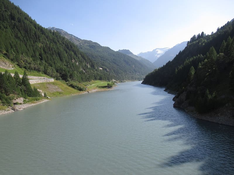
The ruins of Fornet, submerged in the 1950s, have re-emerged from the lowered lake
As you arrive from Valgrisenche, the dam closes off the valley just above Mondanges. After the works the crest, 15.5 m wide, joins the two banks like a bridge, with the lake on one side and the drop down the valley on the other. Behind it the reservoir stretches out, flanked by the road that runs from Bonne to Usellières and Surier; at the far end of the lake, where the water draws back, the walls and bell tower of Fornet remain, the village submerged in the 1950s. On the banks you can see marmots.

Visiting
Reachable by car all year round on regional road 25 as far as Valgrisenche; from Bonne the road runs along the lake on the orographic left as far as Usellières and Surier. Car parks at Mondanges, beside the dam, and at Usellières (2026). At Mondanges there are picnic tables; after the works the dam joins the two banks like a bridge. Along the lake runs a dirt track you can walk or ride by mountain bike from Usellières (1,780 m) to the picnic area at the dam (1,790 m): 4.7 km, 184 m height gain, 1 h 30 each way, difficulty T, from May to October, with the ruins of Fornet along the way. The inside of the dam can only be visited with the operator: free guided tours from July to September 2026, an hour and a half, online booking required, not allowed for children under 6 or for animals, not recommended for anyone who suffers from claustrophobia.
History
The Beauregard dam blocks the Dora di Valgrisenche at the head of the valley, a short way upstream of the main village. It is a double-curvature arch-gravity dam in concrete, built in the 1950s to create a large reservoir for hydroelectric use: 430,000 cubic metres of concrete, a height of 132 m, a crest of 394 m and a planned capacity of 70 million cubic metres, with the maximum level at 1,770 m. The water runs down to the Avise power station through an 11.34 km pressure tunnel and a 1.58 km penstock.
The reservoir submerged five villages inhabited all year round, Beauregard, which gave the dam its name, Sevey, Suplun, Chappuis and Fornet, as well as some alpine pastures. Fornet was the most populous in the valley: before the war it had 45 inhabitants, with a school, a mill, a church and the alpine pastures for cheese, so much so that it was called the Republic of Fornet. The inhabitants left between 1957 and 1960, some for France, others for the neighbouring valleys. A 2006 documentary, Tcheu son ya?, records the voice of a 92-year-old woman who remembers how the dam had to be built and would be built, and wonders what would become of the people, the houses and the lives.
The problems came early. Already in the first years of operation the left slope, above the abutment of the dam, was found to be sliding slowly towards the lake and pressing on the arch, a movement compared to that of the Vajont; downstream, springs appeared. Operation was limited to a few million cubic metres, a small part of the planned capacity, and the lake never again covered the highest villages: the ruins of Fornet re-emerged.
To make the structure safe, the decision was taken to lower it. Between 2011 and 2015 the crest was demolished by 52 m: the dam went down from 132 to 80 m, the crest from 394 to 185 m in length and from 5.6 to 15.5 m in width, and the part visible today is 20 m. The useful capacity is 3.6 million cubic metres, with the maximum level at 1,710 m. In 2015 about a hundred residents asked for the construction track on the right bank to become a road, because the one on the left of the lake had been closed for years due to falling rocks.
Nearby
 Rifugio degli AngeliRebuilt by volunteers carrying the loads on their backs over three summers, 2003 to 2005
 Rifugio Chalet de l'ÉpéeYou climb through the Arolla wood, among larches over five hundred years old
- Valgrisenche SkiOne chairlift and 4 runs in the valley with the longest heliski tradition in Europe
- Valgrisenche Cross-Country TrailsThe trails reach the Beauregard dam, with the Rutor glacier in the background
- Bivacco Luigi RavelliA 10-place bivouac hut from 1982, at the foot of the Grande Rousse between two glaciers
 Col du MontOn 26 January 1945 an avalanche below here swept away 33 Cogne company workers and two Alpini